
When building a common information space, the choice of technology for its creation is very important in terms of the choice of integration platform.
The easiest way to present this problem is by analogy with the automotive industry, which is understandable and close to everyone. As we all understand, no one creates a car from scratch; we take a certain technological platform and design the original engineering solutions around it. It is unlikely that Skoda could become a familiar car around the world if its designers did not have the opportunity to use the Volkswagen platform. The platform removes the headache of engineers in solving basic problems, freeing up time for creativity, but the price is the obligation to comply with certain standards inherent in the chosen platform. And the more open these standards are, the easier it will be, if necessary, to change something in development.
It is exactly the same with software.
All of the world's leading vendors, perfectly aware of the need to create a common information space for corporate customers, offer their own solutions for this task. They are convenient, efficient, but strictly, though not always noticeably, limiting the customer in the choice of separate tools in favor of their own developments to solve particular problems of populating this common information space.
Accordingly, it is in the customers' interest to get rid of such dependence and to replace vendor technology for creating a common information space with something open, to retain all previously implemented software tools without the need for immediate retraining of staff, while opening up opportunities to use the full variety of domestic and freely distributed software.
Below is a list of successful cases of this step-by-step process, supported by a rich functionality of the GIZMOre/cGIS Pro aggregator platform, what we call a "vendor-independent common information space".
These successful cases, unfortunately, are still anonymous due to the requirements of NDAs signed with the customers, but as these projects are completed, the veil of secrecy will be definitely lifted.
Previously the customer to solve this ambitious task was supposed to use the software tool ESRI ArcScene, which, of course, implied the mandatory use of other ESRI tools for creating and editing three-dimensional models, as well as special software interfaces ESRI to develop any applications to solve private tasks of analyzing the common information space of three-dimensional territory model.
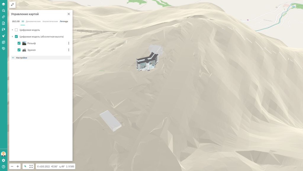
Test operation of the platform-aggregator GIZMOre/cGIS Pro has demonstrated the necessary load capacity for the visualization of up to 1 million objects, with the ability to express the analysis of natural light at a given date and time, visualize the model in the "first person" mode and pleased the customer some convenient new features, which were not in the arsenal of ESRI.
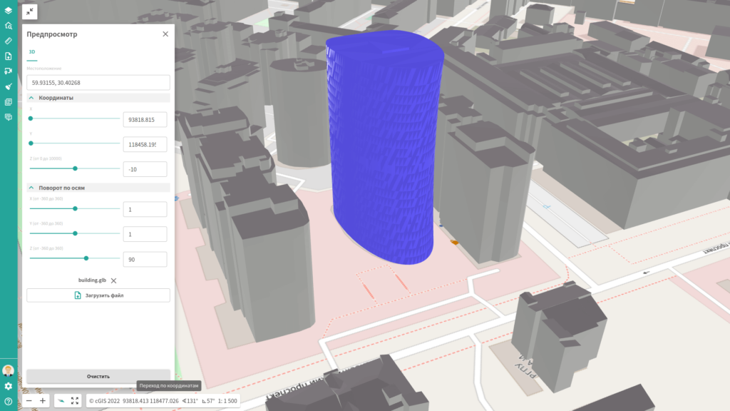
These include the possibility of interactive introduction, directly in the browser into a single information space models of new objects, just brought by designer in a standard format. Previously offered to open a desktop application ESRI, load a new model, and publish the changes within a fairly long time in a common information space for viewing in a browser - feel the difference!
Customers were also pleased that the GIZMOre/cGIS Pro platform supported Cartesian local coordinate systems, sometimes in use during surveying.
As a result, due to the open architecture of the GIZMOre/cGIS Pro platform the customer has an opportunity to use both ESRI desktop solutions without the need to retrain personnel, and the entire variety of local and openly distributed GIS and BIM-tools to populate a common information space.
And arising at the customer needs to solve practical problems using a single information space of three-dimensional model of the territory can be implemented by a wide range of developers, including those who have never worked with ESRI technologies.
In the current situation, the customer uses GeoMedia WebMap to create a common geoinformation space. In this case spatial data are in a single storage based on server DBMS, replenished using desktop GeoMedia, and development of custom applications to solve various industry tasks using spatial data is possible only with the use of specific GeoMedia WebMap API.
The deployment of the GIZMOre/cGIS Pro aggregator platform allowed using the existing spatial data repository without any transformations, but now it can be replenished not only with GeoMedia, but also with any standard GIS-instruments. As an exotic example of supplementing the arsenal of possible tools we can even mention NanoCAD, using our own NanoCAD Database Provider for organizing direct multiuser access to the spatial data repository.
So, as in the previous case, the customer got the possibility to use any spatial data tools and retain the previously purchased desktop licenses of Hexagon to replace them when they expired or when other, more convenient and efficient tools become available.
Yes, the Autodesk-ESRI alliance precisely sets the goal of creating a common GIS-BIM information space, but it firmly follows the marketing strategy of Henry Ford: "You can choose any color car, as long as it is black".
That is, a spectacular visualization of a single information space in Autodesk Infraworks is possible if you solve the problem of GIS using ESRI exclusively, and BIM-design tasks - only using Autodesk. Not a very comfortable idea for a corporate customer these days.
We have surprised the sophisticated public by demonstrating that complex terrain, spatial data and BIM models can be displayed and analyzed in a browser, but the available arsenal of design and survey tools can be supplemented with a wide range of tools, without requiring immediate abandonment of still valid licenses.
The described examples of our vendor-independent approach evoke the most positive response from the customer and give us confidence that the principle "Together, not instead of" is shared by more and more experts, as we declared when creating the GIZMOre/cGIS Pro aggregator platform.